

Post by Admin on Aug 10, 2016 17:55:22 GMT
The general Avebury groundplan and numbered stone location map shown below is an independent drawing viz. illustration by Andis Kaulins based on the English Heritage map of “the Avebury Circles” found in Caroline Malone, The Prehistoric Monuments of Avebury, English Heritage, London, 1994, reprinted 2001, www.amazon.com/Prehistoric-Monuments-Avebury-Caroline-Malone/dp/1850742537. We have added the geometric lines. Markings are larger than on the English Heritage map and the buildings have been removed. “North” is up and “South” is down. The upper right-hand corner KEY designates a map-numbered filled black dot as a standing stone, a filled black elongated horizontal symbol as a fallen stone, an empty black dot as a stonehole (plinth marker) and an empty horizontal symbol as a stonehole (location estimated). Stone I is not on the English Heritage map but is included here. The KEYS are a bit changed from what is used by English Heritage as we think that our amended version is more easily understandable.
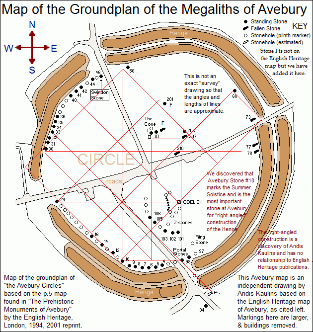
Early in the decipherment process we discovered that Avebury Stone #10 marked the Summer Solstice point in the stars. Please note that this is not the same as "Solstice risings".
Pinpointing the likely astronomical significance of Avebury Stone #10 was of eminent importance for the process of understanding the original construction of Avebury Henge and its Circles, and we shall be producing our decipherment of Avebury Stone #10 shortly.
We drew a 45-degree line from Stone #10 through the Obelisk, leading to Avebury Stone #73, presuming it marked the Winter Solstice in the stars. Examination of angles and linear relationships showed that straight lines and simple 45° and 90° angles greatly explained much of the Avebury Henge construction, indeed, tying together most of the important aspects of construction with just a few lines.
One consequence of this geometric formation was the hypothesis that the earthwork part of the henge represented the Milky Way, seen as two adjoining strands with differing length ends, as in the sky (as above, so below) with the large opening to the West marking the Milky Way's thinnest, most open, part.
That analysis further suggested that Avebury Stone #24 might mark Crux, the Southern Cross, which led this author ultimately to locate a seminal work by Nicholas R. Mann: Avebury Cosmos: The Neolithic World of Avebury henge, Silbury Hill, West Kennet long barrow, the Sanctuary & the Longstones Cove.
Mann suggests that the Milky Way was an essential part of the stellar model that led to the construction of Avebury Henge, and we say that he is right.
His main point is that the ancients had become aware of axial precession, which was "lowering" the sky, and, indeed, at the time of the construction of Avebury Henge, was dropping the stars of Crux, previously fully visible, slowly out of sight.
A Milky Way that was previously fully visible to the ancients for thousands of years was now in part disappearing into the more southern world beyond the horizon. We recall here with more significance now a legend about the otherwise fearless ancient Old Norse that the only thing that they feared was "that the sky was falling". In truth, it was.
In our decipherment of the Avebury megaliths, Avebury Stone #24 marks Crux.
Consult our decipherments of the varous Avebury Stones for more information.


