|
|
Post by Admin on Aug 10, 2016 17:43:05 GMT
Map of the Avebury Groundplan
The Avebury groundplan and numbered stone location map below is an independent drawing viz. illustration by Andis Kaulins based on the English Heritage map of “the Avebury Circles” found in Caroline Malone, The Prehistoric Monuments of Avebury, English Heritage, London, 1994, reprinted 2001, www.amazon.com/Prehistoric-Monuments-Avebury-Caroline-Malone/dp/1850742537.
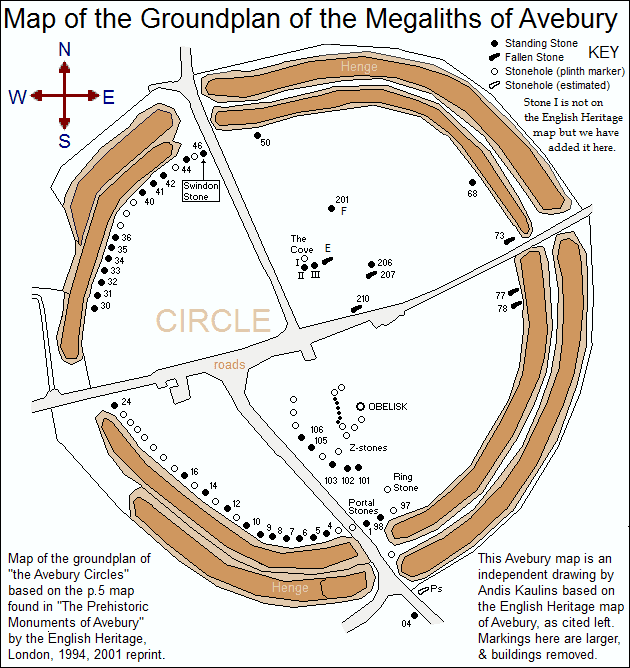
Markings here are larger than in the English Heritage Map and the buildings have been removed. “North” is up and “South” is down. The upper right-hand corner KEY designates a map-numbered filled black dot as a standing stone, a filled black elongated horizontal symbol as a fallen stone, an empty black dot as a stonehole (plinth marker) and an empty horizontal symbol as a stonehole (location estimated). Stone I is not on the English Heritage map but is included here. Those keys are a bit changed from what is used by English Heritage as we think that our amended version is more easily understandable.
Please note that we are not convinced that circle-essential stones belonging to the present circle of stones once filled the markers now marked with plinths. The reason for that will become self-evident as the stones are deciphered.
|
|
|
|
Post by dar on Aug 19, 2016 16:31:41 GMT
Andis: your series of emails on Avebury has brought my attention to that site. I have several observations:
1. The openings (the roads) in the ditch and bank look like major site lines for astronomical observation.
2. I have a book by Aubrey Burl on Avebury. I have not read it yet because I can't get past the many b/ W and color photos of the stones. The photos are not super good quality but good enough to pick out faces and other carved images. Some of the stones look like statues from the waist up, with nearly photo realistic sculpted faces. Others are more schematic where natural features have been enhanced to suggest faces.
3. How does fair use work? Just site the work, borrow their drawing no need for permission?
4. I am looking at sun and moon standstills and nodes and see several places where the viewing angles are the same for sun and moon events. At this latitude, that can be an eclipse predictor.
5. I am researching 3d and computer lighted photography. I am thinking about a proposal to photograph standing stones, document their carvings, and since it would be such a big job, recruit volunteers to photograph local stones. The photos could be put online with the idea to change people's attitude about the past and to preserve the sites.
|
|


